
Альпи - Альпы - Алпи - Алпите - Альптар - Кӯҳҳои Алп
ალპები - આલ્પ્સ - आल्प्स - เทือกเขาแอลป์ - Ալպեր - ஆல்ப்ஸ்
アルプス山脈 - 阿尔卑斯山 - 阿爾卑斯山 - 알프스 산맥
האלפים - אלפן - الألب - الپس - آلپ ←
1-Alpine identity
1.1 Overview
1.2 Definitions
1.3 Etymology
2-Natural habitat of the Alps & environmental factors
2.1 Territorial limits and alpine space dimensions
2.3 Mountain range
2.4 Geology
2.5 Geomorphology
2.7 Climate
2.8 Glaciology
2.9 Hydrography
2.10 Disasters
2.11 Vegetation
2.12 Flora
2.13 Fauna
2.14 Protected areas
3-History
3.1 Prehistory
3.2 Antiquity
3.4 Middle Ages
3.5 Renaissance
3.7 XIX° century
4-Diversity & territorial homogeneity
4.1 Cartography
4.2 Geopolitic
4.3 Wars
4.4 Policies for sustainable development
4.5 Boundaries
4.8 German Alps
4.9 Austrian Alps
4.10 French Alps
4.11 Italian Alps
4.12 Slovenian Alps
4.13 Swiss Alps
4.14 Alpine Microstates
4.15 Alpine Convention
5-Culturals & traditionals factors
5.1 Farmer Society
5.3 Religions
5.4 Legends
5.5 Habitat
5.6 Museum
5.7 Gastronomy
6-Art & legacy
6.1 Literature
6.2 Photography
6.3 Cinema
6.4 Music
6.5 Plastics arts
6.6 Heritage
7-Activities & infrastructures
7.1 Alpine economy
7.2 Industry
7.3 Agriculture
7.4 Craft
7.5 Transhumance
7.6 Fair and market
7.7 Hydroelectricity
7.8 Road network
7.9 Railway
8-Tourism & leisure time
8.1 Tourism
8.2 Alpinism
8.3 Hike and outdoor activities
8.4 Winter sport
8.5 Speleology
8.6 Guides
8.7 Mountain huts
8.8 Alpine Club
8.9 Thermalism
9-Prospects
9.1 Changes
9.2 What futur ?
10-Also...
10.1 Dictionary - Loving dictionnary
10.2 Geographics equivalent words
10.3 External Links
10.4 General bibliography
10.5 Alps weather
10.6 Web cartography :
Geoportail-IGN - OSM - Map Compare OSM - ArcGIS-ESRI - Google Maps
Mapquest - Maps-for-free - Maptoolkit - Bing Maps - Yahoo - Wikimapia10.7 Homoalpinus-Capleymar maps
10.8 Coordonates GPS - Elevation - Elevation and coordonates - Elevation profile
10.9 Map projection
click on the map to view the geographic coordonates
- View Larger Map
![]()
Special thanks to :
Sergio Marazzi, Dr. Werner Bätzing, Dr. Paul Zahn, Dr. Claus Roderich Mattmüller, Dr. Reinhard Mang, Luca Priuli, Riccardo Decarli,
Thierry Dumont, Bernard Debarbieux, Manfred Perlik, Dr. Drago Perko, Mauro Hvratin, Dr. Samuel Nussbaumer,
David Rumsey, Wolfger Mayrhofer, Marcella Macaluso, Antonella Morelli, Alessandra Ravelli, Monika Schneider-Jakob, Joerg Klingenfuss, Francis Ivaldi, Brigitte Montoy,
ZRC SAZU-Anton Melik Geographical Institute Ljubljana, Universitätsbibliothek der Universität Wien, Bibliothek des DAV-München, IUGA de Grenoble, Biblioteca civica di Varese, Biblioteca nazionale del Club Alpino Torino
ALPINE CONVENTION, UIAA, CAF, CAI-SAT, CAS, DAV-OEAV-AVS
DATA-GIS
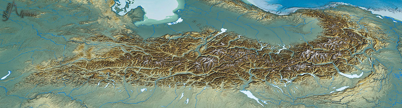
Alps map Proj_Desc : UTM Zone 32/WGS84/meters
Area : 718373142332 sq m (718373,14 km²)
Coordonnates : West longitude : 3° 15' 17.0505" E — North latitude 49° 10' 10.5790" N — East longitude 17° 27' 47.2277" E — South latitude 42° 43' 14.3054" N
Terrestrial elevation data :
NASA Shuttle Radar Topography Mission (SRTMGL1) Global 1 arc second (30 m)
ALOS Global Digital Surface Model 1 arc-second (30 m)
ASTER GDEM 1 arc-second (30 m)
SRTM 90 m Digital Elevation (3 arc-seconds)
Bathymetry data :
GLOBAL MULTI-RESOLUTION TOPOGRAPHY (GMRT) (Bathymetry 100 m resolution)
Ryan, W.B.F., S.M. Carbotte, J.O. Coplan, S. O'Hara, A. Melkonian, R. Arko, R.A. Weissel, V. Ferrini, A. Goodwillie, F. Nitsche, J. Bonczkowski, and R. Zemsky,
Global Multi-Resolution Topography synthesis, Geochem. Geophys. Geosyst.
EMODnet Digital Terrain Model 0.125 arc-minutes (230 m) (GEBCO Digital Bathymetry)
NOAA -NGDC (National Geophysical Data Center)
Global Bathymetry and Elevation Data : SRTM15 PLUS 15 arc-seconds resolution (~500 m) - SRTM30 PLUS 30 Arc-seconds resolution (~900 m)
ETOPO1 Global Relief Model
1 Arc-Minute